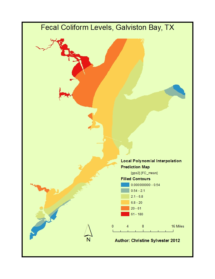
The purpose of the lab is to generate a watershed sediment transport index value and compare to previously published values. Channel stability: “is the ability of a stream
First step is to generate the watershed using the DEM downloaded from Michigan CGI. Next Extract the watershed extent from the flow accumulation surface using the Spatial Analyst Tools/Extraction/Extraction by Mask. The mask data is the watershed you delineated.
Once the DEM is clipped to the extent of the watershed, run the slope tool and get the slope of the watershed. Finally, run the sediment transport formula in the raster calculator. The syntax is:
Power(“FlowAccumulationArea”/22.13,0.6) * Power(Sin(“Slope_Extrac1”/0.0896),1.3)
The Grand Traverse Bay watershed is located in beautiful northwest Michigan’s Lower Peninsula and drains approximately 976 square miles of land. The watershed is one of the larger ones in the State of Michigan and covers major portions of four counties: Antrim, Grand Traverse, Kalkaska, and Leelanau.
Grand Traverse Bay comprises 132-miles of Lake Michigan shoreline from its northwest tip at the Leelanau lighthouse to its northeast tip at Norwood. The bay spans 10 miles at its widest point, stretches a lengthy 32 miles to its base in Traverse City, and has its deepest point at 590 feet. Grand Traverse Bay is one of the few remaining oligotrophic embayments in the Great Lakes and arguably has the highest water quality of the larger Lake Michigan bays. Oligotrophic is a term applied to lakes that are typically low in accumulated nutrients and high in dissolved oxygen, both of which are characteristics of high quality waters. Lakes such as these are clear and blue and most often cold, much like the Grand Traverse Bay.
Sediment
|
• Quality is good, typically coarse sand with numerous areas of cobble and gravel; at 100+ft depth the bottom is silt and clay
• Increases in silt and organic detritus along near shore bottom
• Isolated areas that are relatively rich in inorganic matter (i.e., Omena Bay)
• Sediment does not contribute significant concentrations of nutrients to water column; most of the phosphorus in the sediment is organically bound
• There are few rooted macrophyte beds (possibly due to lack of suitable substrate)
• Seiche events (which are large scale periodic movements of water) can re-suspend sediments in deeper portions of the bay. If carried into the water column, they can release contaminants deposited decades ago.
|
Pollutant or Environmental Stressor
|
Designated Uses Affected
|
Sediment
|
Coldwater Fishery
Other Indigenous Aquatic Life
Navigation
|
That study was followed by an extended Water Quality Study conducted by an independent consulting firm. That analysis considered samples consistently drawn from the lake in the spring and summer each year from 1993 through 2001. The study considered several measures of water quality including temperature and dissolved oxygen, conductivity, total alkalinity, nitrate nitrogen, chlorophyll a, pH and total phosphorous. The results of these individual samples and the trends they indicate are presented in a Lake Water Quality Index which the study authors indicate provides an accepted measure of water quality which can be used for comparative studies. This study confirmed the elevated levels of phosphorous in bottom sediments, but overall gave Long Lake water quality indices ranging from 93 to 100 on a scale of 1 to 100. In fact, the authors indicate that, “Long Lake is the only lake we’ve studied that ever had a Lake Water Quality Index of 100.”